COLORADO

Dave

Adventurist
Founder
Senior Staff
Editor
Crowd Sourced! Share information and ask specific questions about this state here.

This section is focused on documenting the following:
  • Adventure Opportunities & Destinations
  • Trails
  • Campsites
  • Watercraft Put-Ins/Take-Outs
  • Local Info, Highlights & Lore
  • Local Regulations & Local Insight

IMG_0274.JPG
 
For weary traveler coming from the west coast or even just a state or two away this is a AWESOME place to camp for a night or two and explore the area. I present to you... Rabbit Valley

It is reached via I 70, we had just finished a drive across UTAH in a matter of hours, about 7 with stops. We had left the day before from San Diego around 1400 for our longest trip of the year to Colorado, got to bed in St. George around 2200 MST and left in the morning for a quick peak into Zion NP before continuing on our way to Colorado. The speed limit was a blistering 80 MPH, my sister (we sent a picture of a sign to my sister, the Police Officer) responded,"So you can drive 90!?". It was a long day but we were determined to get to Colorado.

Rabbit Valley is an OHV area that borders Utah and Colorado, I had my doubts about it due to it being OHV.
When we arrived there wasn't a sole to be seen, specifically no toy haulers, no dust clouds. Navigation around the area was fairly simple, all we had was a paper map of the area from the trail head, which provided little to no assistance except where camp areas were.
IMG_9406.jpg


The gravel road ahead appeared to be groomed for RVs and other weekend warriors, but that didn't last long. We soon found smaller more rocky "fun" trails. After hundreds of miles on the free way, my transfer case was itching to get into 4wd, so we had a little bit of fun on side trails, knowing the summer sun would be up for quite a bit longer.

IMG_9422.jpg


After driving around for while we decided to try and get to the mighty Colorado river, perhaps for a swim? The map provided no elevation information so we set out toward the "river" marked on the map. When we arrived at the first campsite, we knew THIS was the one.

IMG_9437.jpg


We set up camp, and had some adult beverages. After the seemingly long trip from San Diego, we were in "The Centennial State".

IMG_9464.jpg

Due to the lack of people, by lack of I mean 0, we decided to get wild (which is not like us) and take a shower without a shower tent. It was pretty funny at first but the the views were stunning and I would probably never have the opportunity to take a shower with this view again.
IMG_9463.jpg


IMG_9454.jpg


Every couple of hours a train would come by, it wasn't loud though due to it being down in the canyon and there was no reason for it to sound its whistle. It was quite a site to see, I like to try and imagine the grueling work of laying tracks being slightly better in areas like this.
IMG_9459.jpg


The next morning we packed up camp, ate breakfast and headed back out to the road, which was only a mile or two away.
IMG_9536.jpg


So, for the weary traveler, or the destination camper, Rabbit Valley is beautiful and right off the I 70.
IMG_9565.jpg
IMG_9566.jpg
 
I'll definitely be exploring this area when I head to Rifle for the Fall. Thanks for sharing Rabbit Valley! It's perfect for studying geology and fossils!
 
Last edited:
Wow, I've missed this every time I head to Colorado National Monument. Stupid highway. Def going to have to explore that.
 
Machelle and I have been to the Silverton area a couple of times. There are some awesome trails in that area.
 
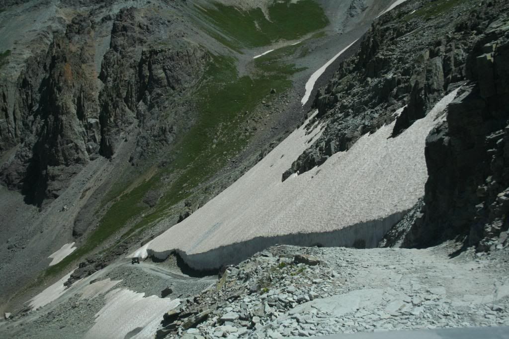
^^^^ Black Bear Pass isn't really that bad. After seeing some of your other pics, I think you could make it just fine in your truck (wouldn't take the trailer though). There is a lot of shelf road with some exposure, one slightly tricky part at the top of the falls, and then some switchback turns getting down into Telluride.
 
^^^^ Black Bear Pass isn't really that bad. After seeing some of your other pics, I think you could make it just fine in your truck (wouldn't take the trailer though). There is a lot of shelf road with some exposure, one slightly tricky part at the top of the falls, and then some switchback turns getting down into Telluride.

I wouldn't take a full size over Black Bear Pass personally. Maybe a mid size like the Tacoma. Maybe. The problem with the pass is, there are two sections where the majority of accidents occur, and if they do occur, you are F'd. I recall recently that the local Sherrif in Telluride wants it closed because it uses up all their resources. (https://expeditionportal.com/sheriff-calls-for-the-closure-of-black-bear-pass-to-motor-vehicles/)

Black-Bear-Pass-Jeep_1409592921897_7682104_ver1.0_640_480.jpg


It's def not a trail you should ever go alone on.


All that said, there was a guy on the colorado4x4.org who took his Power Wagon over it.
BlackBear7-19-1460.jpg~original


No thank you.
 
I followed a buddy in an F250 over Black Bear Pass. Sure, there is some risk, but it can be done.

Part of the trail, pic was taken in early August.
silverton2011213_zps7b33bb6f.jpg
 
Colorado road trip (via Flagstaff/Sedona) commences in less than a week.

:stars

We will be camping at Morefield CG inside Mesa Verde NP and riding the Phil's World trails with our MTB's.


:bike

Pics and text to follow...
 
Looking for a trail? Colorado has released an online map with 39,000 miles of them across the state
DENVER – All your hiking trail needs for the summer can now be found in one place, thanks to Colorado Parks and Wildlife, who have created a comprehensive online guide to more than 39,000 miles of trails across the state.
The Denver Post reports the Colorado Trail Explorer map spans 226 jurisdictions and includes 17,099 trails as well as 1,431 trailheads. It also includes 5,683 miles of hiking trails, 6,821 miles of mountain biking trails, 24,906 miles of motorized trails and unpaved roads, and 1,746 miles of paved bike trails.
You can access the Colorado Trail Explorer map by clicking here
But the gargantuan project is just beginning.
A parks and wildlife Geographical Information Systems (GIS) analyst told The Post the Colorado Trail Explorer guide only details about 85 percent of the state’s trails, adding that they’re working to make this an updatable map.
The project is part of Governor John Hickenlooper’s “Colorado the Beautiful Project,” an initiative with the intent to get Coloradans interested in healthy outdoor activity. The goal of the plan is to have every Colorado live within ten miles of park, trail or vibrant green space in the course of a generation.

Original link: https://www.thedenverchannel.com/li...zQxsGk7oxh4GTdlD6XIa05IRQCAZdQqmyXo4jTC0punG4
 
Back
Top Bottom