2019 in Review

justjames

Adventurist
Okay Ladies and Gents, here’s my first crack at a trip report. Or should I say, three trip reports. We’re both recently retired and wanted to see the sights. I’ve been very fortunate over the years and have traveled and camped extensively on 2 wheels. I took photos and told great tales upon my return but as you all know, it ain’t like seeing it yourself. So, with that in mind, it was time to show Mrs. justjames what she had been missing.

Early in 2019, the Mrs. and I decided to take a couple of days of off-road driving classes. This was in preparation for what we hoped would be a year of vehicle based adventure travel. Fortunately, Overland Experts NC division is local to us. Here is a shot of the truck on the way home after day one. It was cold and muddy in Uwharrie NF in early February but you would be amazed where The Mrs successfully drove my truck, impressed!

Training Day 1.jpg


Late in the month we headed south towards Big Bend NP. We stopped to see friends in the “Big D” and went to a Texas sized BBQ joint, or at least the grill was. The food was great and as you can see from my profile, I like good food.

Texas BBQ Cooker.jpg


Next was Big Bend. After checking into the park and getting our campsites assigned, we drove Old Ore Road from south to north camping about half way through. It was pretty rough in places and we took turns driving. The Mrs. did great.

Big Bend Old Ore Rd.jpg


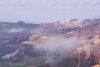
If you’re wondering, it was a little cool, probably got down to 40 that night but it was a “dry” cool. We had heard that sunsets and sunrises last longer in Big Bend than anywhere. I can’t understand why but they were pretty spectacular. It was also a full moon, which I captured the next morning at sunrise.

Sunset-Big Bend Style.jpg


Sunrise on Full Moon.jpeg


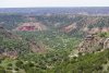
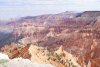
We spent 4 days and nights in Big Bend camping at a new location each night. All the campsites were on 4WD back roads in some pretty remote areas. I think we drove every dirt road with the exception of Old Maverick which was all washboard in 2007 when I did it on my motorcycle and from the reports we received, it hadn’t improved.

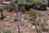
The next shots are some of the flora and fauna, the first is flowers on the cliff banks of the Rio Grande and the others are just various flowers, which were in bloom.

Banks of Rio Grande.jpg


desert Flowers.jpg


More Desert Fauna.jpg


For some reason my truck developed a few rattles. I couldn’t figure it out, do you see anything wrong?

Truck Started Rattling.jpg


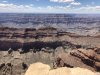
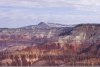
From BBNP we continued on west to Big Bend Ranch State Park. It is even more remote and probably more arid than the National Park. If you want solitude and spectacular scenery, you’ve got to check it out! If I recall correctly, we saw one other 4wd vehicle and one bicycle in our 3 days there. Here’s a taste of one of their roads.

The Road Home.jpg


Next we headed into Hill Country for a few days and encountered 3 straight days of fog. I can’t tell you much about it since we actually saw very little except fog. Planning our escape, we decided to head north and check out the Ouachitas and Ozarks. The forecast deteriorated while in route so after much dilemma, we turned back east to NC. (more to follow)
 
Last edited:
As you may have noticed, I was sporting a GoFastCamper on my Tacoma during the Big Bend trip. You may have also noticed that the Mrs and I are not exactly spring chickens. The GFC is a great product and the people who own the company are nothing but great! Having said that, the bed is 50” wide and after about 48 years on a king size bed, the Mrs said something had to change. So you married folks out there understand all the “If Mama ain’t happy” stuff……..

Here’s our new home for the road less traveled.
Our New Home.jpg


I’ve been a Toyota guy for many years so we sold the Mrs’ old 4Runner and bought a lightly used 2015 4Runner Trail Premium. I added a few things to “spruce it up” and in early June we were off.

First we crossed the Georgia Traverse from east to west and in June, it is a long green tunnel of trees. Beautiful in its own right but we were looking for wide open spaces.

Ga Tra 1.jpg


Ga Tra 2.jpg


Ga Tra 3.jpg


Once we crossed the Alabama state line we hit the highways headed west. After crossing the Mississippi, the first few miles of Arkansas were underwater. For a NC guy, I’d never seen this type of flooding.

Flood.jpg


Onward we went to north Texas looking for Palo Duro and Caprock Canyon State Parks .

PD sign.jpeg


PD1.jpeg


PD2.jpeg


From there we headed southwest across the panhandle of Texas headed for New Mexico. I’ll just say that there is a lot of wheat farming in the panhandle and not much else. You also don’t need a weather report, you can see it coming.

Storm.jpg


Once in NM we skirted around the missile range down to Truth of Consequences to hose down and resupply. Out intentions were to wander our way over and pickup the Continental Divide Trail. Since the snows were still impassible in Colorado we figured going south was a good idea. New Mexico doesn’t disappoint!

NM Road.jpg


Here are our first 3 campsites in NM. The first was actually in a state run campground and I felt like we were on the set of Bonanza. The second was just a little dispersed site at a little over 9,000 feet in elevation. The mountain across the way is actually a ski resort, which we didn’t know until the next morning when the sun hit it just right to see the lifts. Number 3 was dispersed in a high pasture and once again, I could hear the theme song of Bonanza.

1st nite NM.jpeg


9k Camp NM.jpeg


UNADJUSTEDNONRAW_thumb_3556.jpg


More coming...........
 

Attachments

  • PD3.jpeg
    PD3.jpeg
    421.4 KB · Views: 55
Last edited:
While in NM we saw parts of Gila, Lincoln, Cibola and Carson National Forests as well as a few wildlife areas and a National Monument. I could spend several weeks in any of them but you know, so many roads, so little time………

NM backrd.jpg


NM br2.jpg


NM BR3.jpg


Next we found ourselves in the teaming metropolis of Pie Town and guess what we had? PIE!! They had a special on blueberry & peach and I’ll have to say, it was yummy.

PIE.jpeg


For no particular reason, we found ourselves on the Chain of Craters road. I had no idea how many places in NM had lava flows. Little ones and big ones, so big you could drive a semi through big. We hiked a couple of these and it was surprising to find flowers and plants blooming up through what appeared to me to be 100’ thick lava rock.

lava flower.jpg


lava 1.jpg


lava2.jpg


lava3.jpg


At the north end of the Chain of Craters road we found a tourist trap called the Bandera Volcano and Ice Cave. Pretty weird that it can be 110 at the top of the steps but at the bottom, its always 30 degrees. Some enterprising fellow in the 1800’s opened a saloon there and had the coldest beer west of the Pecos. In fact, it was the only cold beer west of the Pecos.

ice cave.jpg


After the ice cave we continued north and rolled into Gallup. Needing baths, laundry and an oil change we checked into a hotel for the evening. With the amazing powers of the interwebs we learned that much of the CDT north of Gallup was still closed due to snow. The next morning we committed to a day of asphalt and embarked for the North Rim.
 
Last edited:
Our intentions were to camp at the campground below the Navajo Bridge in Marble Canyon and we got there at about 5:30 pm. There were several hours of sunlight remaining and it was 104 degrees. Sorry, it may have been a dry heat but I’m not pitching a tent in that so we rolled on up the hill towards Jacob Lake. After gaining about 5,000 in elevation we found a side road on BLM land and stopped for the evening. It was a frigid 78 when we set up camp. I got my chair out and watched the sun set against the Vermillion Cliffs. We took a bunch of photos, which I promptly lost so you’ll just have to wait till the next day when we go to the North Rim, ha!

First we go to the Kaibab NF office at Jacob Lake to get maps and tips on what to do and so forth. The volunteer on duty was most gracious and we went across the parking lot to the service station and filled up with gas and water. So off we go into the great spectacle of tourists at the North Rim proper and inspite of all the hub-bub, it is still most impressive. We walked around the area until we couldn’t take the crowds any more and went back out of the park a short distance and turned east on 216 and wound our way to the edge of Tater Canyon and set up camp. Solitude!

Everything at the North Rim proper has been documented by those much better qualified than me with much better cameras but you gotta see it to believe it.

PtSub.JPG


I’ll leave it alone and take you along the North Rim as we saw it from east to west. The first two shots below are from Point Imperial which is east of the main touristy areas then Angels Window which is west. Next is Dragon Point and the last two from Crazy Jug.

GC1.JPG
NR4.JPG
Angels window.JPG
Dragon.JPG
Crazy Jug.JPG
CJ2.JPG


We camped just past Crazy Jug on the edge and watched thunder showers down in the canyon below us. It was indeed “Crazy”. There was a nice fire ring so we built a fire as the sun set and had a great evening until about midnight when the thunderstorms reached us. Quite a bit of wind and the fire ring came back to life and was showering a trail of sparks down into the canyon. I was envisioning the headlines, “Idiot tourist burns down the Grand Canyon!” I grabbed our Nemo Helio and quickly sprayed the fire into submission and the Grand Canyon survived.
 
So we woke up the next morning and did a little strategizing. This was day 4 since getting gas and we had done a considerable amount of 4LO. Our next known destination was Toroweap but we figured we needed a little go-juice first. We were really enjoying the Kaibab NF so we decided to cut back northeast to Jacob Lake and fuel up. Just before getting there we ran into a downpour and once we got cell reception, the forecast for the day was heavy rain until late afternoon. We decided to change course and head for Fredonia on FR22 and from there take asphalt up to Kanab. There were great views of the Colorado Plateau along this route and there were lots of people in Kanab. There were even vehicles for rent, whoda thunk it? We found a “cheap” hotel with laundry facilities and checked in for the tourist experience.

COLO plat.jpg
kanab.jpg


The next morning we headed to Pipe Springs ranger station where we nabbed a camp permit for the Tuweep CG and then set off onto dirt. 90ish miles later this is what we found.

toroweap.jpg
toro 2.jpg


Here’s our campsight, can you see our Shiftpod2 hiding in the middle?

tuweep.jpg
cgsign.jpg


This was the third week of June and it was pretty warm that afternoon so I got my DeWalt 20V fan set up in the tent for The Mrs and then pulled my chair out into the road which had a little shade from one of the trees. So here’s the scene, warm breeze, shade, comfy chair, old man, snore…..

My slumber was interrupted by the sound of gravel crunching in the road near where I was relaxing. It startled me as I hadn’t heard an engine so I look up and here comes a Ranger on a mountain bike at a pretty good speed. He stops and we chat for a few minutes where I learn he has been posted here for 11 years, alone. He was a super nice guy and seemed to be living the life he relished. If memory serves me, the ranger station is 6 miles from the campground and is a very rough road.

road.JPG


He said he rides it in 18 minutes. He was loaded with a plate carrier, backpack, duty belt complete with a Sig P220 and 3 spare mags, radio, cuffs, etc. I’m guessing 40 pounds of gear. Damn I feel old.
 
The next morning we decided to make the trek over the Mt. Trumbull Wilderness to see the school. That’s it in the first picture, the little white speck to the right of the long straight. Great shot, huh? We actually spent about 45 minutes inside looking at pictures and the history of the area. Those people were tough.

mt trumbull wild.JPG
mt1.JPG
mt2.JPG
mt3.JPG


From there we back tracked a few miles to see the petroglyphs before taking Route 5 north to Colorado City. There were all sorts of new flowers in this area so The Mrs took lots of photos. The petroglyphs were pretty cool too.

flow2.JPG
flow3.JPG
flow4.JPG
pet1.JPG
pet2.JPG
pet3.JPG


The hike in to see the petroglyphs was about a mile each way. It had a very well maintained path and was all downhill going in and had me wanting an ATV on the way out.

Next we're headed to Zion and take a shortcut.............
 

Attachments

  • Flow1.JPG
    Flow1.JPG
    1.1 MB · Views: 52
Last edited:
Thanks for taking the time to do this write up and add the pics. I'm really enjoying this and please keep it going!! Although it's still going to be a couple three years until I retire, my wife and I would like to pack up and go see this amazing nation of ours together.
 
Once in Colorado City we fueled up and headed for Zion NP which has always been my favorite. The Tuweep Ranger told us to look for Smithsonian Butte Road for a great scenic shortcut. It was and we began to see rocks and mountains like nowhere else but Zion.
sb1.jpg
sb2.jpg


We camped about half way through surrounded by awesome views. These next shots were all taken within a 5 minute walk of our tent.

sb4.JPG
sb3.JPG
sb5.JPG
sb6.JPG


The next morning we eased on through Smithsonian Butte at a slow pace because it was a very dangerous road, mainly due to the fact I couldn’t keep my eyes on the road because of the scenery. As I mentioned earlier, the Zion area is special to me because I find the red rock vistas amazing. That is probably because it’s the exact opposite of what I’m used to in North Carolina. Anyway, Smithsonian Butte dropped us onto Utah Hwy 9 just west of the entrance to the NP.

We stopped for fuel and water and observed the absolute onslaught of traffic heading into the park. I’d read reports of Zion’s overcrowding problems and unfortunately we were headed right into the fray. Being a grumpy old fart and not liking crowds we decided to go back west a little ways and explore Hurricane Mesa Road north all the way to Smith Mesa. This skirts all the way up the western side of Zion and proved very scenic as well.

hm1.JPG
hm2.JPG
hm3.JPG


I later learned those above shots were probably Zion Ranch. Smith Mesa took us out to Kolob Terrace Rd which goes to the northern sections of Zion which had a surprising amount of greenery compared to all the red rock in the south.

zn1.JPG
zn2.JPG
zn3.JPG
zn4.JPG


We back tracked south and headed through the park. I’m sorry to say it was bumper to bumper. Zion has turned into Southern California, beautiful but too many people!
 
After battling our way through the congestion we exited the park on the east side and took the first left onto North Fork Rd going north into the Dixie National Forest. We drove all the way to Navajo Lake seeing more great scenery and it was a long day as we did over 170 miles arriving at Duck Creek CG as the sun was setting. Here’s a few shots from along the way.

dixi1.JPG
dixi2.JPG
dixi3.JPG
dixi4.JPG


The next morning broke cold and clear and we headed for Cedar Breaks National Monument. This took us to our highest elevation of the trip so far with several of the viewpoints being over 10,000 feet. That’s high for an east coast guy! The rangers were scrambling for their cameras and told us it was the first time in over 3 years they had seen clouds in the amphitheater.

cb cloudy.JPG
cb3.JPG

cb1.JPG


We tried to drive up the road to Brian Head ski resort which is over 11,000 feet but it was still blocked by snow. I haven’t figured out why the road to a ski resort would be blocked by snow but I digress……. It was late June so maybe the skiers had had enough.
 

Attachments

  • cb1.JPG
    cb1.JPG
    611.6 KB · Views: 52
  • cb2.JPG
    cb2.JPG
    648.3 KB · Views: 51
  • cb3.JPG
    cb3.JPG
    386.6 KB · Views: 54
  • cb a1.JPG
    cb a1.JPG
    333.9 KB · Views: 48
Since we’d gotten an early start we turned towards Bryce Canyon and actually arrived there along with a few hundred other people in time for lunch. We’d spent time here a few years ago so we kept trucking.

bctunnel.JPG
bc1.JPG


Next stop was Kodachrome Basin State Park. It was jam-packed with campers and relatively small so we drove through and snapped a few pics. I won’t tell you what The Mrs said about some of the geologic features found there.

kcb1.JPG
kcb2.JPG
kcb3.JPG
kcb4.JPG


Kodachrome Basin SP is on the western edge of Grand Staircase-Escalante and we spend the next 3 days there. Cottonwood Canyon then the most spectacular campsite I’ve ever seen………….
 
Absolutely amazing! I just called my wife over to share this with me. She has been to some of those parts but I have not. I'm sitting here getting very excited about retirement and our plans to take a few months and go see all of this.
 
Absolutely amazing! I just called my wife over to share this with me. She has been to some of those parts but I have not. I'm sitting here getting very excited about retirement and our plans to take a few months and go see all of this.

Well I'm glad you're both enjoying it. We had a great time and hope to do more next summer into fall. Hopefully, we will do more of the Rockies which we missed this year due to the record snowfall and then all the way up to Alaska!

As far as retirement, I've found my calling! Finally, something I'm good at! It is great to get up everyday and only do what you want to do as opposed to what you have to do.

I hope you have many years of doing what you want to do because we all know you have spent enough time doing what you had to do...
 
Back
Top Bottom