MICHIGAN

Dave

Adventurist
Founder
Senior Staff
Editor
Crowd Sourced! Share information and ask specific questions about this state here.

This section is focused on documenting the following:
  • Adventure Opportunities & Destinations
  • Trails
  • Campsites
  • Watercraft Put-Ins/Take-Outs
  • Local Info, Highlights & Lore
  • Local Regulations & Local Insight

IMG_0237.JPG
 
Here is a link to Michigan DNR's ORV trails page. You can run 4x4s on ORV Routes. You will need an ORV License and Tail Permit. The 2 biggest attractions in Michigan are Silver Lake Sand Dunes and Drummond Island.

http://www.michigan.gov/dnr/0,4570,7-153-10365_15070_15080-38330--,00.html

Here is a map of Drummond Island. I recommend this place over the sand dunes if you have a short attention span or low tolerance for others and loud vehicles.

http://www.drummondislandchamber.com/drummond_island_map.html
 
I'm looking at a trip to the U.P. this spring/summer - any info on good dispersed campsites etc is much appreciated!
 
Did you make the trip last summer?

I did. I hit the Porcupines area and on up to the north shore of Superior and Minnesota. I’ll be back this summer, headed the other direction, Copper Harbor etc
 
I did. I hit the Porcupines area and on up to the north shore of Superior and Minnesota. I’ll be back this summer, headed the other direction, Copper Harbor etc

Sweet. A friend and I are heading up late September / early October for a 8 day overlanding trip. We're meeting up in St. Ignace and pavement-hauling my Trooper up to Copper Harbor, and slowly working our way back to St. Iggy on as many backroads and ORV routes as we can, camping, fishing and fat biking along the way.
 
I'm researching a backpack trip now - float plane from Houghton area to Isle Royale NP for a week :)

isle-royale-regional-map.jpg


The least visited National park in our system, the epicness of a week here on foot or by kayak, completely unsupported, has me geeking out big time. It reeks of Adventure.

(you can apparently travel by canoe, lake-to-lake, across the beam of Isle Royale, portaging across as needed. Another fun trip idea...)

river-map-isle_royale.jpg
 
Yeah buddy - that would be insane! Isle Royale is one of those once-in-a-lifetime destinations...! That canoe/portage the length sounds epic!!!
 
1) This makes me Homesick!
2) Jealous!!
3) If you haven't been to "The Arrowhead" of Minnesota (Ely, MN.) put it on your list (Not September/October, the black fly's WILL eat you).
4) Be careful, on Superior the weather can turn faster than anywhere I've ever seen.

Insane? NO, well maybe?:canoe
:kayakOnce-in-a-Lifetime, I hope not!


LakeSuperior-vs-EastCoast.jpg


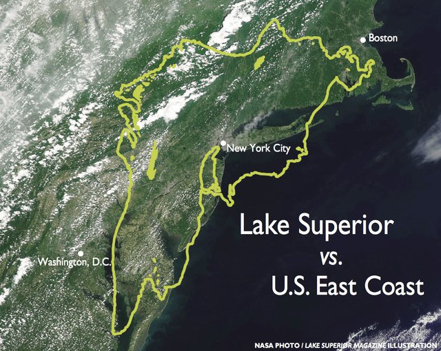
Steve Colman, now retired from the University of Minnesota Duluth's Large Lakes Observatory, uses this comparison with the U.S. East Coast to explain the size of the Big Lake.

Raising Lake Superior's level by a single inch requires 551 billion gallons of water, but even that enormous sum is a mere drop in the Big Lake bucket.

It's the world's largest freshwater lake by surface area – 31,700 square miles (82,100 square kilometres), or roughly the size of Maine – and holds 10 percent of the world's surface fresh water. (By volume, it's the third largest, behind Lake Baikal in Siberia and Lake Tanganyika in eastern Africa.)

Lake Superior's 3 quadrillion gallons are enough to cover both North and South America under a foot of water!

Here's another (preposterous) way to think about it: Downing half a gallon of water daily, it would take you 16.4 trillion years to drink Lake Superior. Or the entire world population of 7 billion people, each person drinking half a gallon per day, could together polish off Lake Superior in 2,348 years.

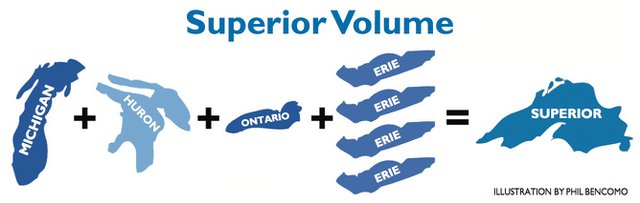
The Big Lake holds as much water as all of the other Great Lakes combined plus three more Lake Eries. To reach its deepest point, you'd need to descend 1,276 feet – about the distance of a ride down from the top floor of Chicago's 108-story Willis Tower.

Lake Superior is so large and so deep that its retention time – about how long an average drop of water remains in the Lake – is 191 years. For Lake Michigan it's 99 years, Huron 22, Ontario 6 and Erie just 2.6 years. No wonder ours is called Superior.

superior-volume.jpg

Lake Superior has as much water as the rest of the Great Lakes combined – plus three more Lake Eries.

More facts
Length: 350 miles (560 kilometres)

Width: 160 miles (260 kilometres)

Volume: 3 quadrillion gallons, or 2,900 cubic miles (12,100 cubic kilometres)

Shoreline: 1,826 miles (2,938 kilometres)

Average depth: 483 feet (147 metres)

Maximum depth: 1,276 feet (389 metres)


It's been 12/15 years since I've been on the BIG Lake, I'm tearing up thinking about it! This is so awesome GO FOR IT!
:riverrafting
 
It really is an amazing region on so many levels, looking forward to seeing as much as we can. :map
 
Hey Michiganiacs!

Any of you guys and gals heard about the Keweenaw Adventure Overland Retreat (KOAR), being held this September 13-16? Looks like a pretty good time...just trying to get the word out there! I think my buddy and I may be changing our plans and doing our run a bit earlier in the year.
 
Circle Lake Michigan Write-Up Part 1 written by my wife, Brittany
For more pictures, check out our website:
https://www.lonestaradventurer.com/circle-around-lake-michigan

IMG_2758.jpg


Clockwise or counter-clockwise? This was our initial debate as we were planning our route around Lake Michigan. At first we decided to go north (clockwise) and leave Saturday morning, but Topher got home Friday sooner than expected and we were eager to start the trip. So we decided to leave and changed our initial route to go south traveling counter-clockwise around the lake which turned out to be a better use of time. We hit the road and set our sights towards the first destination, Silver Lake State Park. We hoped to beat the traffic out of Chicago, but unfortunately, I am not sure that is ever possible. We arrived at Silver Lake later than expected; partly due to we had forgotten to take into account the 1-hour time change. We quickly got checked it, set up camp, and then took a stroll to the beach to put our feet in the beautiful blue water. As the sun sat low on the horizon and highlighted the sand dunes across the lake we were treated to an amazing sunset. After returning to camp we planned out the next day as we fixed up a batch of Korean tacos for dinner before calling it a night.

IMG_2799.jpg


The following morning we got up around 0630 took our showers, got the baby (Kaylee) ready, grabbed a Poptart for breakfast and made our way over to Mac Woods to catch their 0930 dune ride. If you are in the area, you should definitely check this out. Much to our surprise Kaylee could not stop smiling or laughing the entire ride. She loved the breeze in her face and the slopes of the hills. At first, she crunched into a small ball every time we went down one, but by the middle of the trip she was putting her hands in the air as if she were on a roll roaster. Our tour guide, Joe had no shortage of corny jokes that added to the fun.

IMG_2822.jpg
IMG_2871.jpg
IMG_2884.jpg


After the dune ride, we set our GPS and headed to Crystal Lake. When we got there the lake reminded us of tropical waters and made us slightly miss our time spent in Hawaii. We took a short cruise around the edge of the lake along the M-119 as we were worked our way up to Sleeping Bear National Shoreline. This night we gambled on a first come, first serve campground in the area and unfortunately everywhere close by was full. So instead of wasting time and daylight and pushing our limit with our 8 month old at the time. Kaylee’s tolerance in the car seat is only around 3 hours at one time, we decided to take the Pierce Stockton Scenic loop and stop and walk around the lookouts. We joyfully watched about 2 dozen people many of whom did not have a pleasant look on their face attempt the climb back up from the shoreline of the lake.

IMG_2926.jpg
IMG_2950.jpg
IMG_2962.jpg


As we pushed towards Traverse City to see if the state forest campgrounds had any openings. We got lucky and found a spot at Scheck's Place State Forest Campground nestled along the Boardman River. After unpacking we took a stroll around the rustic campground and checked out the river and picked wild apples before setting up camp and making lettuce wraps for dinner. The mosquitoes started coming out around 9 and that meant it was time for us to retreat to the safety of the camper. It actually got pretty chilly that night, down to around 55 degrees and it was a bit of a rough night for Kaylee as the cooler temps made her a bit congested causing her to waking up several times during the night.

20180811_201903.jpg
20180811_203838.jpg


The next morning, all of us got up, made some oatmeal, packed up and hit the road. Topher set our route to Mackinac City via the M-119’s Tunnel of Trees and then caught the Star Line ferry over to Mackinac Island. After grabbing some whitefish tacos at the Pink Pony, we took the horse carriage tours around the island, where we were able to enjoy the Arch Rock and the historic Fort Mackinac! After the tour, we got back to camp around 7:30, cooked up some mini English muffin pizzas and took a walk around the camp. We walked out to the lake and played a little bit, visited with a couple that had a little pop-up camper for a motorcycle and then checked out the camp store. Kaylee was starting to get fussy for bed, so we gave her a quick outdoor shower (which she absolutely did not like as it was hard to adjust the temperature without wasting too much water) and then fed and laid her down. I whipped up some s’mores for dessert before the fire was completely out and then called it a night.

IMG_3030.jpg
IMG_3027.jpg
IMG_3067.jpg
20180812_160917.jpg


The next day was planned to be semi short to give us all a break from being in the truck. With a stop at the famous Great Lakes Ship Museum. The history of Lake Superior and the multitude of shipwrecks, including that of the legendary SS Edmund Fitzgerald, is quite interesting. They had several buildings you could walk through and by paying a $5 donation, you could go up to the top of the lighthouse and see the view. There was also a deck you could walk out on or even walk to the beach. The lake looked like glass and is so hard to believe that it could get so bad as to have 30ft+ waves that have taken out so many ships. Getting hungry, we stopped at the Brown’s Fishery House and enjoyed some local whitefish and chips (very yummy).

20180813_141057.jpg
20180813_145544.jpg
20180813_160743.jpg


We then checked out the Tahquamenon lower falls before camping at the Rivermouth campground. This was a neat little campground with modern facilities and electricity. We had the second campsite from the river and had some fun playing on the little beach there, which was a perfect spot for launching a canoe. We spotted a few crawfish and played around with them with Kaylee. We circled the two loops of the campground to check out the different rigs. Still full from lunch, we had a potstickers for late dinner and then settled down to watch a movie, make our plan for the next day, and hit the hay.
IMG_3108.jpg

20180814_173523.jpg
20180814_173850.jpg


Because Monday wasn’t as short as we hoped, we decided to forgo dirt roads and seeing Crisp Point lighthouse and made our way to the log slide overlook. We actually happened to hit a dirt road on the way due to our GPS knowing that we like to explore. The log slide overlook was quite awesome! Warning: take your shoes off before the hike or they will be filled with sand even if you don’t go down the slide. If you get lucky, you will be able to pick some wild raspberries along the trail.

IMG_3105.jpg
 
Circle Lake Michigan Write-Up Part 1 written by my wife, Brittany
For more pictures, check out our website:
https://www.lonestaradventurer.com/circle-around-lake-michigan-part-2


After the hike at the logslide lookout, we set out to find camp along the shoreline to close out our Monday. We backtracked towards Lake Superior and were able to find some boondocking sites right on the lake. It was amazing. We walked the beach, collected a few rocks, and as the temperature began to drop, we started dinner, which that night was hamburger patties with hash browns and corn on the cob. Interesting concoction if you ask me, but we had a slight incident with the fridge popping open after Topher took a bump a bit too fast. (Turns out we busted a shock, as we found out later as we inspected the truck and found the shock covered in oil). As we were cooking dinner, Topher noticed there were wild blueberries all around where we were. So I quickly jumped at the opportunity to pick some after I laid Kaylee down for her nap. I was able to get half of a large cup full before my back began to ache from bending down. We pulled out our chairs and Kaylee’s outdoor mat and nestled on the hill of the beach to eat and watch the sunset, trying to keep an eye out for a moose because it is on our list of want to sees. It was a nice and cool evening and we all slept great listening to the sound of the waves as they crashed on the shoreline.

20180817_164542.jpg

IMG_3162.jpg

IMG_3163.jpg

IMG_3179.jpg


Tuesday, we ventured off down the Pictured Rocks lakeshore to check out the various attractions including Miner’s falls, Miner’s castle, and also Munising falls. We grabbed a pasty at Muldoon’s for lunch and purchased our tickets for the following mornings cruise. We found camp at Au Train, a small two loop primitive campground that has a small beach area and boat launch. We had a hodge podge dinner that night with sautéed chicken sausage and zucchini and fried potatoes. It was actually very good! We attempted to give Kaylee another outdoor shower before the bugs got bad and calling it a night. Let’s just say she was still not a fan!!!

IMG_3203.jpg

IMG_3220.jpg

IMG_3224.jpg


Wednesday morning we woke up early to catch our Pictured Rocks cruise at 11. We wanted a decent spot on the boat that we could take pictures from so we made sure to line up early. There were already a lot of people there when we were. Following the cruise, we grabbed lunch at Johnny’s Dogs where I got the mac attack dog and Topher got the bacon bleu burger and fries. Both were delicious! The burger was huge!!! We ran to a local store to grab some more beverages and a few things we were running low on and then set our way to camp, which we were gracious hosted by Dave Berg and his family to camp at the base of their homebuilt fire tower. We had the opportunity to meet and socialize with him and his daughter Elisa that afternoon and later in the evening his wife joined us and we made up some garlic herb chicken thighs with rice and baked beans for their kind hospitality. The fire tower reminded us of one of those fancy tree houses or tiny living homes. It was really neat! Up at the top was a beautiful view of the tree tops and Lake Superior. On a clear day, you could see for miles. Unfortunately, it wasn’t super clear for us but still beautiful. He said we were welcome to come back and we definitely will have to take him up on the offer. Would love to see what it looks like in the winter, as he said you could see in all directions and also actually catch the sunset or sunrise. We had all intentions of seeing it, but got caught up in the awesome stories sharing camping tips with each other. We can’t thank the Berg family enough for their tips on this trip especially.

20180815_131446.jpg

20180817_161429.jpg

20180817_161446.jpg

20180817_161503.jpg

20180817_161634.jpg

20180817_161705.jpg

20180817_162504.jpg


The following morning was even more overcast and foggy. We stopped at Presque Isle state park and Little Presque Isle, however, couldn’t see much of anything so we figured the hike up Sugarloaf Mountain wouldn’t be worth it. So this saved something to do and see for the next trip.


IMG_3418.jpg

IMG_3435.jpg

IMG_3450.jpg


Passing this up, we set our path south to stop at the Palms book state park and see the Kitchitikipi Spring. This was pretty cool. The water was such an amazing turquoise color and they stock it with fish each year. As we were waiting in line to catch the cable drawn barge that goes out into the middle and back, we watched the fish (some of the which were 2-3 feet long). We wanted to keep the day semi short so once again decided to forgo the Fayette Historic Township and we found camp at the Flowing Well campground in the Hiawata National Forest.

IMG_3477.jpg

IMG_3485.jpg

IMG_3496.jpg

IMG_3500.jpg


Knowing we had quite a bit of laundry to wash, Topher needed a haircut for work and I start class up again on Monday, we decided to push home Saturday instead of visiting Door county. There was just too much wanted to do and see up there so we decided to make a mini trip out of it another weekend. With 6 hours ahead of us, we knew we had to stop to at least get out to stretch our legs and get Kaylee out of the car seat for some time. So using my navigation and research skills, I found the Fonferek’s Glen City Park that had a season waterfall. As we arrived, it was nestled in a farmer’s backyard so it was quite interesting. And it turns out there hasn’t been enough rain lately and it was not the “season” for the waterfall, but it was still a really cool place to walk around and see the riverbed and imagine what it would be like with water.


IMG_3513.jpg

Overall this was an incredible trip. Every day there was something new and cool to see! From a tire sensors going back, to headlights going out, to breaking a shock, there was never a dull moment. With the beautiful views, the gorgeous water, the amazing tours, and Kaylee’s giggles and smiles will make this trip a lifetime memory!
 
Back
Top Bottom